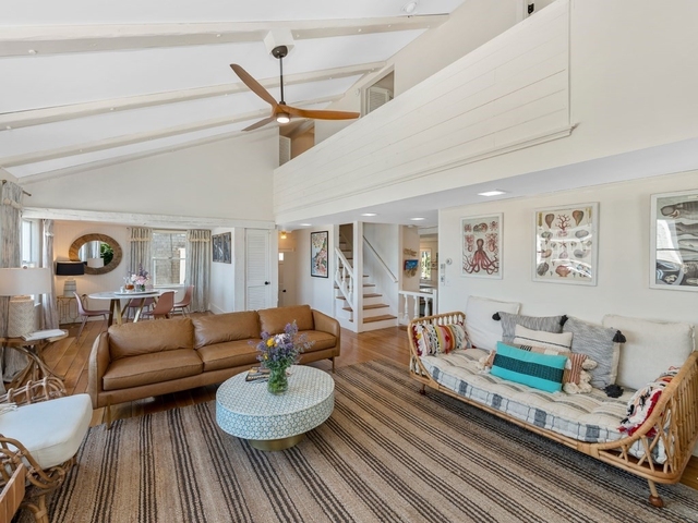
Welcome to 9 Landmark Lane, a building located in Rockport in Rockport, MA.
As a quick overview, these are the most up-to-date information we've collected about the property.
The building itself was built in 1959.
This is a single story building.
Finally, 9 Landmark Lane was most recently sold on Aug 2, 2019 for $842,500.
According to local assessors, the total value of the building is currently valued at $960,300.
Specifically, the value of the land that the property sits on has been assessed at $487,300.
The building was last assessed in 2024.
Here's what we know about the features and amenities in this building.
While there is no garage access for residents, you will probably be able to find a local garage to park your car at instead.
We are not sure what system the building uses for cooling.
Sadly, informaton related to the heating system was not disclosed.
Are you a fan of fireplaces? Good news! This property has one single fireplace.
There is no porch or patio on the premise of the property.
For those who love to swim, you'll want to check out community pools nearby as this particular property does not have a swimming pool.
The local assessor's office has not provided us with information related to the roof cover material and the type of roof the building has.
Policies
Dogs Allowed
Facts
General
Year Built
1959
Effective Year Built
2001
Building Count
1
Total Rooms
8
Bedroom Count
3
Bathroom Count
3
Full Bathrooms
3
Partial Bathrooms
3
Building Condition
Good
Building Quality
unknown
Construction Type
unknown
Building Style
Conventional
Exterior Walls Type
Wood siding
Interior Walls Type
unknown
Roof Shape Type
Gable
Roof Cover Type
Asphalt
Floor Count
1
Living Units
2
Floor Cover
unknown
Basement Type
Unfinished basement
Basement Area
750
Garage Type
unknown
Parking Space Count
0
Patio Type
unknown
Porch Type
unknown
Pool Type
unknown
Unit Count
Building Floor Area
Floor Area Ratios
Building
Building Type
unknown
Property Class
Residential
Land Acres
0.277
Standard Land Use Code
Duplex (2 units, any combination)
County Land Use Code
unknown
Ownership
Current Owner
BRESNAN MICHAEL W
Current Owner's Name
BRESNAN MICHAEL
Current Owner 2
BRESNAN SHERRY MARY
Current Owner 2's Name
BRESNAN SHERRY MARY
Previous Owner
SEAL DARWIN L
Previous Owner's Name
SEAL DARWIN L
Previous Owner 2
SEAL JEAN A
Owner Address - City
GLOUCESTER
Owner Address - State
MA
Owner Address - ZIP Code
01930
Owner First Name
MICHAEL
Owner Last Name
BRESNAN
Second Owner First Name
SHERRY
Second Owner Last Name
BRESNAN
Second Owner Middle Name
MARY
Owner Before Previous Owner
BISSELL JOYCE H EST
Owner Before Previous Owner 2
BISSELL
Vacant Flag
Address Standardization Based
Vacant Flag Date
Mar 15, 2024
Neighborhood
School District Name
Rockport School District
School Tax School District
ROCKPORT SD
Census Tract
220102
Census Block Code
1037
Census Group
1
Census Year
2021
Census - Combined Statistical Area - Area Code
148
Census - Combined Statistical Area - Area Name
Boston-Worcester-Providence, MA-RI-NH-CT
Census - County FIPS
25009
Census - Full FIPS
250092201021037
Census - Metropolitan Division - Area Code
15764
Census - Metropolitan Division - Area Name
Cambridge-Newton-Framingham, MA
Census - Metro Micro Statistical Area - Area Code
14460
Census - Metro Micro Statistical Area - Area Name
Boston-Cambridge-Newton, MA-NH
Census - Metro Micro Statistical Area - Area Type
metropolitan
Census Source
US Census Bureau
Census State FIPS
25
Census Tract Code
220102
School District - Unified - Grade High
12
School District - Unified - Grade Low
PK
School District - Unified - LEA Code
2510200
School District - Unified - Name
Rockport School District
Zoning
Zoning
RA
Geography
Account Number
739
District
252
Parcel
ROCK M:10 B:81A
Block
81A
Lot
81A
Lot Code
unknown
Municipality
ROCKPORT
Latitude
42.6715
Longitude
-70.6248
FIPS
25009
Mailing Carrier Code
C026
Mailing Full Street Address
718 WASHINGTON ST
Mailing House Number
718
Mailing Street Mode
ST
Mailing Street
WASHINGTON
Mailing 4-Digit Zip Code
1374
Geo Status Code
unknown
Valuation
Timestamp
2024-03-18 19:21:44
UCID Flag
C
More About The Building
In total, the building area is listed as 2,430 square feet.
The building itself has 4,320 square footage of total floor area.
Fun fact, were you aware that buildings can shift depending on temperatures outdoors? This might remind you of middle school science classes, but heat will cause most materials to expand while the cold will cause them to contract. As a result, many architects and engineers often have to make sure that control joints are made up of the right materials and in good condition.
The building class code for 9 Landmark Lane is unknown but given the importance of this information, we will work to update this data as soon as possible.
Interested in learning more about the neighborhood that the property is located in?
Buildings in the 01966 area have a median price of $5,000.
Those in the 25th percentile, have a price around $5,000.
While those in the 75th percentile, have a price around $5,000.
Typically, the buildings in this area have a median sqft of 2,750.
That means that the median price per sqft is around $2.
In other words, the price per sqft for buildings in the 25th percentile is $2.
While the price per sqft for buildings in the 75th percentile is $2.
As a breakdown, we've included the following stats:
There are currently no studio listings being advertised in the area.
There are currently no one bedroom listings being advertised in the area.
There are currently no two bedroom listings being advertised in the area.
There are currently no three bedroom listings being advertised in the area.
There is currently a single advertised four bedroom listing.
School zoning information and other data are provided by
RealtyHop Schools and 3rd party sources.
The contents of the database are not guaranteed to be accurate or timely.
Contact the schools or districts before making any decisions using on this data.