330 Clay Street, San Antonio, TX 78204
Lone Star, East Side, San Antonio Central
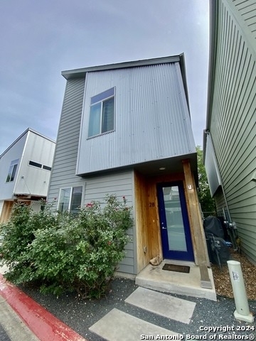
Welcome to 330 Clay Street, a building located in Lone Star, East Side, San Antonio Central in San Antonio, TX.
As a quick overview, these are the most up-to-date information we've collected about the property.
The market value for the land that the building sits on has been listed at $2,854,810.
In addition, improvements upon the building have an added value of $2,480.
In total, the total market value of the property as a whole is $2,857,290.
According to local assessors, the total value of the building is currently valued at $2,857,290.
Specifically, the value of the land that the property sits on has been assessed at $2,854,810.
The building was last assessed in 2023.
Here's what we know about the features and amenities in this building.
While there is no garage access for residents, you will probably be able to find a local garage to park your car at instead.
We are not sure what system the building uses for cooling.
Sadly, informaton related to the heating system was not disclosed.
There is no porch or patio on the premise of the property.
For those who love to swim, you'll want to check out community pools nearby as this particular property does not have a swimming pool.
The local assessor's office has not provided us with information related to the roof cover material and the type of roof the building has.
Facts
Building Condition
unknown
Construction Type
unknown
Exterior Walls Type
unknown
Interior Walls Type
unknown
Building
Property Class
Residential
Subdivision
CLAY STREET HOMES CONDOMINIUMS
Standard Land Use Code
Condominium unit (residential)
County Land Use Code
unknown
State Land Use Code
unknown
Legal Description 1
NCB 15 BLK 1 LOT 15 **MASTER FILE/COMMON ELEMENTS** (CLAY STREET HOMES CONDOMINIUMS) 2017-NEW PER CONDO DECL. 17771/1692 EXE 3-30-16. JF/GIS/4-18-16.
Ownership
Current Owner
GROOM JOSHUA
Current Owner's Name
GROOM JOSHUA
Previous Owner
NARDONE KEVIN ROBERT
Previous Owner's Name
CANSLER ASHLEY RENEE
Previous Owner 2
KRISTAN NICOLE
Owner Address - City
SAN ANTONIO
Owner Address - ZIP Code
78204
Owner Before Previous Owner
PSW URBAN HOMES LP
Ownership Rights Codes
Single/unmarried man
Neighborhood
School District Name
San Antonio Independent School District
School Tax School District
57 SA030
Census - Combined Statistical Area - Area Code
484
Census - Combined Statistical Area - Area Name
San Antonio-New Braunfels-Pearsall, TX
Census - County FIPS
48029
Census - Full FIPS
480291501001006
Census - Metro Micro Statistical Area - Area Code
41700
Census - Metro Micro Statistical Area - Area Name
San Antonio-New Braunfels, TX
Census - Metro Micro Statistical Area - Area Type
metropolitan
Census - Place FIPS
4865000
Census Source
US Census Bureau
School District - Unified - Grade High
12
School District - Unified - Grade Low
PK
School District - Unified - LEA Code
4838730
School District - Unified - Name
San Antonio Independent School District
Geography
Mailing Carrier Code
C015
Mailing Full Street Address
330 CLAY ST UNIT 2
Mailing 4-Digit Zip Code
2466
Geo Status Code
Prior to setting the GEOsource field the default value was 'P'.
Valuation
Timestamp
2024-01-24 05:50:07
More About The Building
Fun fact, were you aware that buildings can shift depending on temperatures outdoors? This might remind you of middle school science classes, but heat will cause most materials to expand while the cold will cause them to contract. As a result, many architects and engineers often have to make sure that control joints are made up of the right materials and in good condition.
The building class code for 330 Clay Street is unknown but given the importance of this information, we will work to update this data as soon as possible.
Interested in learning more about the neighborhood that the property is located in?
Buildings in the Lone Star area have a median price of $2,200.
Those in the 25th percentile, have a price around $1,998.
While those in the 75th percentile, have a price around $2,575.
Typically, the buildings in this area have a median sqft of 1,464.
That means that the median price per sqft is around $2.
In other words, the price per sqft for buildings in the 25th percentile is $1.
While the price per sqft for buildings in the 75th percentile is $2.
As a breakdown, we've included the following stats:
- There are currently no studio listings being advertised in the area.
- There is currently a single advertised one bedroom listing.
- There are currently a total of 2 two bedroom listings.
The median price for these types of listings is $2,350.
That's $1.85 price per sqft.
- There are currently a total of 3 three bedroom listings.
The median price for these types of listings is $2,200.
That's $1.47 price per sqft.
- There is currently a single advertised four bedroom listing.
About The Area
330 Clay Street is located in 78204.
There are 11,723 people living here.
There are 4,251 households.
Most of these households have an average family size of 3.64 people.
According to the census, 43% are currently renting while 57% own their homes.
The median age of this population is around 37.9 years old.
On average, most folks in the zipcode are unmarried.
About 62% of folks speak a language other than English in this area.
The area's employment rate is currently around 55.6%.
Speaking of employment, the median income is $35,392.
Most folks will commute by car for around 21.9 minutes.
Finally, we know that 31% of residents in the area have graduated with their high school degree.
Additionally, 13% and 7% have their Bachelor's and Master's degree, respectfully.
Moving on to the county level.
Bexar County, Texas has a population of 1,858,699 people.
Based on census records, there are 623,321 registered households.
Families in this area are on average made up of 3.61 people per household.
Most folks are unmarried.
They are also typically around 33.2 years old.
Does diversity matter to you? Right now, 40% of folks speak a language other than English here.
About 42% rent while 58% purchased their homes.
Right now, the community is made up of 25% of residents who have graduated with at least a high school degree.
On top of that, 17% have a Bachelor's degree and 10% have a Master's degree.
The employment rate is currently around 59.5%.
Those employed, have a median income of $52,353.
If you move here, you can expect to commute mostly by car for around 24.7 minutes.
Finally, let's take a look at the stats related to San Antonio, TX Urban Area.
The urban area is home to 1,914,755 people.
A total of 646,111 households are registered here.
With average family sizes being listed at 3.58 people.
About 25% of residents have graduated with a high school degree.
Of the rest, 18% have their Bachelor's and 10% have their Master's degree.
Folks speaking a language other than English, make up about 39% of the population.
Looking to move to this urban area? You'll need to look forward to commuting by car for around 24.6 minutes.
Speaking of your commute, 59.7% of people in this area are employed.
The recorded median income is currently at $53,159 per year.
The median population age has been listed at 33.4 years old.
Interestingly enough, unmarried people make up the majority of the population.
Last but not least, renters make up about 42% of the population while homeowners are at about 58% of the population.
PUBLIC TRANSIT
PROBANDT & CEVALLOS
(670 ft - 3 min walk)
VIA Metropolitan Transit
PROBANDT OPPOSITE CEVALLOS
(690 ft - 3 min walk)
VIA Metropolitan Transit
PROBANDT & SIMON
(880 ft - 4 min walk)
VIA Metropolitan Transit
PROBANDT OPPOSITE SIMON
(960 ft - 4 min walk)
VIA Metropolitan Transit
S. ALAMO & PROBANDT
(0.20 mi - 5 min walk)
VIA Metropolitan Transit
Nearby Schools
(within attendance boundary)
2015 S Flores St, San Antonio, TX 78204
Public
•
Elementary
•
Grades PK to 5
San Antonio Independent School District
325 Pruitt Ave, San Antonio, TX 78204
Public
•
Middle School
•
Grades 6 to 8
San Antonio Independent School District
400 Eagleland St, San Antonio, TX 78210
Public
•
High School
•
Grades 9 to 12
San Antonio Independent School District
School zoning information and other data are provided by
RealtyHop Schools and 3rd party sources.
The contents of the database are not guaranteed to be accurate or timely.
Contact the schools or districts before making any decisions using on this data.