2100 Saint Thomas Street, New Orleans, LA 70130
Lower Garden District, Central City - Garden, Orleans
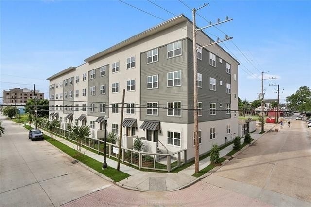
Welcome to 2100 Saint Thomas Street, a building located in Lower Garden District, Central City - Garden, Orleans in New Orleans, LA.
As a quick overview, these are the most up-to-date information we've collected about the property.
Finally, 2100 Saint Thomas Street was most recently sold on Sep 27, 2019 for $244,000.
The market value for the land that the building sits on has been listed at $217,600.
In addition, improvements upon the building have an added value of $3,782,400.
In total, the total market value of the property as a whole is $4,000,000.
According to local assessors, the total value of the building is currently valued at $400,000.
Specifically, the value of the land that the property sits on has been assessed at $21,760.
The building was last assessed in 2018.
Here's what we know about the features and amenities in this building.
While there is no garage access for residents, you will probably be able to find a local garage to park your car at instead.
We are not sure what system the building uses for cooling.
Sadly, informaton related to the heating system was not disclosed.
There is no porch or patio on the premise of the property.
For those who love to swim, you'll want to check out community pools nearby as this particular property does not have a swimming pool.
The local assessor's office has not provided us with information related to the roof cover material and the type of roof the building has.
Facts
Building Condition
unknown
Construction Type
unknown
Exterior Walls Type
unknown
Interior Walls Type
unknown
Building
Property Class
Residential
Subdivision
RESIDENCE JOSEPHINE
Standard Land Use Code
Apartment house (5+ units)
County Land Use Code
unknown
Legal Description 1
SQ 43 ST THOMAS ST & JOSEPHINE ST LOT X1 119.6-40.11/160.5X191/157.1-33.10
Ownership
Current Owner
NAVARRO PHILIP ANDREW
Current Owner's Name
NAVARRO PHILIP ANDREW
Previous Owner
CHANEY DANIEL M
Previous Owner's Name
POPP ARMSTRONG ALISON
Previous Owner 2
CHANEY DUSTIN L
Previous Owner 2's Name
POPP KLEIN NICOLETTE
Owner Address - City
NEW ORLEANS
Owner Address - ZIP Code
70130
Owner Before Previous Owner
LIBERATORE JR VINCENT
Owner Before Previous Owner 2
LIBERATORE NICOLE MARIE TURANSKY
Ownership Rights Codes
Company/Corporation
Neighborhood
School District Name
Orleans Parish School District
Census - Combined Statistical Area - Area Code
406
Census - Combined Statistical Area - Area Name
New Orleans-Metairie-Hammond, LA-MS
Census - County FIPS
22071
Census - Full FIPS
220710141002016
Census - Metro Micro Statistical Area - Area Code
35380
Census - Metro Micro Statistical Area - Area Name
New Orleans-Metairie, LA
Census - Metro Micro Statistical Area - Area Type
metropolitan
Census - Place FIPS
2255000
Census Source
US Census Bureau
School District - Unified - Grade High
12
School District - Unified - Grade Low
PK
School District - Unified - LEA Code
2201170
School District - Unified - Name
Orleans Parish School District
Geography
Mailing Carrier Code
C042
Mailing Full Street Address
2100 SAINT THOMAS ST Apt 105
Mailing House Number
2100
Mailing Street
SAINT THOMAS
Mailing 4-Digit Zip Code
4971
Geo Status Code
Record was coded to interpolated rooftop level
Valuation
Timestamp
2020-03-23 00:00:00
More About The Building
In total, the building area is listed as 30,126 square feet.
The building itself has 30,126 square footage of total floor area.
Fun fact, were you aware that buildings can shift depending on temperatures outdoors? This might remind you of middle school science classes, but heat will cause most materials to expand while the cold will cause them to contract. As a result, many architects and engineers often have to make sure that control joints are made up of the right materials and in good condition.
The building class code for 2100 Saint Thomas Street is unknown but given the importance of this information, we will work to update this data as soon as possible.
Interested in learning more about the neighborhood that the property is located in?
Buildings in the Lower Garden District area have a median price of $2,000.
Those in the 25th percentile, have a price around $1,573.
While those in the 75th percentile, have a price around $2,500.
Typically, the buildings in this area have a median sqft of 780.
That means that the median price per sqft is around $3.
In other words, the price per sqft for buildings in the 25th percentile is $2.
While the price per sqft for buildings in the 75th percentile is $3.
As a breakdown, we've included the following stats:
- There are currently no studio listings being advertised in the area.
- There are currently a total of 20 one bedroom listings.
The median price for these types of listings is $1,848.
That's $2.88 price per sqft.
- There are currently a total of 13 two bedroom listings.
The median price for these types of listings is $2,100.
That's $2.49 price per sqft.
- There is currently a single advertised three bedroom listing.
- There is currently a single advertised four bedroom listing.
About The Area
2100 Saint Thomas Street is located in 70130.
There are 14,055 people living here.
There are 8,045 households.
Most of these households have an average family size of 2.68 people.
According to the census, 70% are currently renting while 30% own their homes.
The median age of this population is around 36.7 years old.
On average, most folks in the zipcode are unmarried.
About 12% of folks speak a language other than English in this area.
The area's employment rate is currently around 67.9%.
Speaking of employment, the median income is $52,360.
Most folks will commute by car for around 18.6 minutes.
Finally, we know that 12% of residents in the area have graduated with their high school degree.
Additionally, 33% and 26% have their Bachelor's and Master's degree, respectfully.
Moving on to the county level.
Orleans Parish, Louisiana has a population of 382,922 people.
Based on census records, there are 154,844 registered households.
Families in this area are on average made up of 3.42 people per household.
Most folks are unmarried.
They are also typically around 35.5 years old.
Does diversity matter to you? Right now, 9% of folks speak a language other than English here.
About 54% rent while 46% purchased their homes.
Right now, the community is made up of 23% of residents who have graduated with at least a high school degree.
On top of that, 21% have a Bachelor's degree and 15% have a Master's degree.
The employment rate is currently around 55.8%.
Those employed, have a median income of $37,488.
If you move here, you can expect to commute mostly by car for around 23.7 minutes.
Finally, let's take a look at the stats related to New Orleans, LA Urban Area.
The urban area is home to 950,293 people.
A total of 369,631 households are registered here.
With average family sizes being listed at 3.32 people.
About 29% of residents have graduated with a high school degree.
Of the rest, 18% have their Bachelor's and 11% have their Master's degree.
Folks speaking a language other than English, make up about 13% of the population.
Looking to move to this urban area? You'll need to look forward to commuting by car for around 24.2 minutes.
Speaking of your commute, 58% of people in this area are employed.
The recorded median income is currently at $45,222 per year.
The median population age has been listed at 36.8 years old.
Interestingly enough, unmarried people make up the majority of the population.
Last but not least, renters make up about 44% of the population while homeowners are at about 56% of the population.
Nearby Schools
(within attendance boundary)
709 Park Blvd, New Orleans, LA 70114
Public
•
Elementary
•
Grades PK to 3
Orleans Parish School District
3019 Canal Street, New Orleans, LA 70119
Public
•
High School
•
Grades 9 to 12
Orleans Parish School District
4238 St. Charles Avenue, New Orleans, LA 70115
Public
•
Secondary School
•
Grades 9 to 10
Orleans Parish School District
School zoning information and other data are provided by
RealtyHop Schools and 3rd party sources.
The contents of the database are not guaranteed to be accurate or timely.
Contact the schools or districts before making any decisions using on this data.