1701 West Alabama Street, Houston, TX 77098
Neartown - Montrose, Central Houston, Houston
Nearby Active Listings

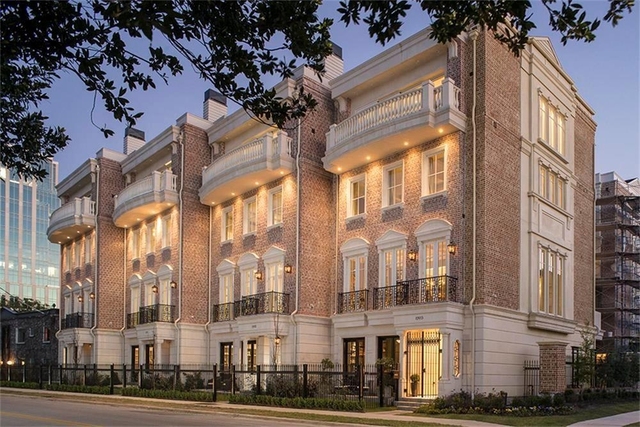
Welcome to 1701 West Alabama Street, a building located in Neartown - Montrose, Central Houston, Houston in Houston, TX.
As a quick overview, these are the most up-to-date information we've collected about the property.
The building itself was built in 2011.
The market value for the land that the building sits on has been listed at $24,629,685.
In addition, improvements upon the building have an added value of $8,095,432.
In total, the total market value of the property as a whole is $32,725,117.
According to local assessors, the total value of the building is currently valued at $32,725,117.
Specifically, the value of the land that the property sits on has been assessed at $24,629,685.
The building was last assessed in 2022.
There is another building on the same land that 1701 West Alabama Street was built on.
Here's what we know about the features and amenities in this building.
While there is no garage access for residents, you will probably be able to find a local garage to park your car at instead.
We are not sure what system the building uses for cooling.
Sadly, informaton related to the heating system was not disclosed.
There is no porch or patio on the premise of the property.
For those who love to swim, you'll want to check out community pools nearby as this particular property does not have a swimming pool.
The local assessor's office has not provided us with information related to the roof cover material and the type of roof the building has.
Policies
Cats Allowed
Dogs Allowed
Facts
Effective Year Built
2011
Building Condition
Average
Construction Type
Masonry
Exterior Walls Type
Brick
Interior Walls Type
unknown
Patio Type
Patio - screened
Location Influence Type
unknown
Building
Building Type
Exterior non-combustible materials/Interior combustible materials
Property Class
Commercial
Subdivision
LANCASTER CENTER R/P
Standard Land Use Code
Grocery, supermarket
County Land Use Code
unknown
State Land Use Code
unknown
Legal Description 1
RES B BLK 1 LANCASTER CENTER R/P
Ownership
Current Owner
MONTROSE REAL ESTATE PARTNERS LTD
Current Owner's Name
MONTROSE REAL ESTATE PARTNERS LTD
Previous Owner
ABERCROMBIE FAMILY INTERESTS LTD
Previous Owner's Name
TEXAS ABERCROMBIE FAMILY INTERESTS LTD
Owner Address - City
SAN ANTONIO
Owner Address - ZIP Code
78283
Owner Last Name
MONTROSE REAL ESTATE PARTNERS
Owner Before Previous Owner
ALABAMA & DUNLAVY LTD
Ownership Rights Codes
unknown
Current Owner Is a Corporation Indicator
Yes
Neighborhood
School District Name
Houston Independent School District
School Tax School District
HOUSTON ISD
Census - Combined Statistical Area - Area Code
288
Census - Combined Statistical Area - Area Name
Houston-The Woodlands, TX
Census - County FIPS
48201
Census - Full FIPS
482014108003002
Census - Metro Micro Statistical Area - Area Code
26420
Census - Metro Micro Statistical Area - Area Name
Houston-The Woodlands-Sugar Land, TX
Census - Metro Micro Statistical Area - Area Type
metropolitan
Census - Place FIPS
4835000
Census Source
US Census Bureau
School District - Unified - Grade High
12
School District - Unified - Grade Low
PK
School District - Unified - LEA Code
4823640
School District - Unified - Name
Houston Independent School District
Geography
Assessors Map Reference
5356A
Account Number
1327190010002
Municipality
CITY OF HOUSTON
Mailing Carrier Code
B100
Mailing Full Street Address
PO BOX 839999
Mailing Street
PO BOX 839999
Mailing 4-Digit Zip Code
3999
Valuation
Timestamp
2023-09-22 04:46:13
More About The Building
In total, the building area is listed as 76,372 square feet.
The building itself has 76,372 square footage of total floor area.
Fun fact, were you aware that buildings can shift depending on temperatures outdoors? This might remind you of middle school science classes, but heat will cause most materials to expand while the cold will cause them to contract. As a result, many architects and engineers often have to make sure that control joints are made up of the right materials and in good condition.
The building class code for 1701 West Alabama Street is unknown but given the importance of this information, we will work to update this data as soon as possible.
Interested in learning more about the neighborhood that the property is located in?
Buildings in the Neartown - Montrose area have a median price of $1,800.
Those in the 25th percentile, have a price around $1,300.
While those in the 75th percentile, have a price around $2,532.
Typically, the buildings in this area have a median sqft of 951.
That means that the median price per sqft is around $2.
In other words, the price per sqft for buildings in the 25th percentile is $2.
While the price per sqft for buildings in the 75th percentile is $2.
As a breakdown, we've included the following stats:
- There are currently a total of 18 studio listings.
The median price for these types of listings is $1,104.
That's $2.24 price per sqft.
- There are currently a total of 191 one bedroom listings.
The median price for these types of listings is $1,410.
That's $2.08 price per sqft.
- There are currently a total of 123 two bedroom listings.
The median price for these types of listings is $2,337.
That's $1.84 price per sqft.
- There are currently a total of 32 three bedroom listings.
The median price for these types of listings is $3,333.
That's $1.52 price per sqft.
- There are currently a total of 7 four bedroom listings.
The median price for these types of listings is $5,000.
That's $1.80 price per sqft.
About The Area
1701 West Alabama Street is located in Harris County, Texas.
There are 4,434,257 people living here.
There are 1,536,259 households.
Most of these households have an average family size of 3.52 people.
According to the census, 45% are currently renting while 55% own their homes.
The median age of this population is around 32.9 years old.
On average, most folks in the county are unmarried.
About 43% of folks speak a language other than English in this area.
The area's employment rate is currently around 63.5%.
Speaking of employment, the median income is $55,584.
Most folks will commute by car for around 28.6 minutes.
Finally, we know that 23% of residents in the area have graduated with their high school degree.
Additionally, 19% and 11% have their Bachelor's and Master's degree, respectfully.
Moving on to the urban area level.
Houston, TX Urban Area has a population of 5,393,559 people.
Based on census records, there are 1,846,252 registered households.
Families in this area are on average made up of 3.52 people per household.
Most folks are unmarried.
They are also typically around 33.3 years old.
Does diversity matter to you? Right now, 42% of folks speak a language other than English here.
About 42% rent while 58% purchased their homes.
Right now, the community is made up of 22% of residents who have graduated with at least a high school degree.
On top of that, 21% have a Bachelor's degree and 12% have a Master's degree.
The employment rate is currently around 63.6%.
Those employed, have a median income of $60,376.
If you move here, you can expect to commute mostly by car for around 29.2 minutes.
$1,104
Studio Median Rent
PUBLIC TRANSIT
Richmond Ave @ Dunlavy St
(0.26 mi - 6 min walk)
Metropolitan Transit Authority of Harris County
Richmond Ave @ Dunlavy St
(0.27 mi - 6 min walk)
Metropolitan Transit Authority of Harris County
Richmond Ave @ Woodhead St
(0.27 mi - 6 min walk)
Metropolitan Transit Authority of Harris County
Richmond Ave @ Woodhead St
(0.29 mi - 7 min walk)
Metropolitan Transit Authority of Harris County
Richmond Ave @ Mandell St
(0.31 mi - 7 min walk)
Metropolitan Transit Authority of Harris County
Nearby Schools
(within attendance boundary)
5100 Hazard St, Houston, TX 77098
Public
•
Elementary
•
Grades PK to 5
Houston Independent School District
2600 Woodhead St, Houston, TX 77098
Public
•
Middle School
•
Grades 6 to 8
Houston Independent School District
3325 Westheimer Rd, Houston, TX 77098
Public
•
High School
•
Grades 9 to 12
Houston Independent School District
School zoning information and other data are provided by
RealtyHop Schools and 3rd party sources.
The contents of the database are not guaranteed to be accurate or timely.
Contact the schools or districts before making any decisions using on this data.